


feings GS 01 2023

mimilolo
User
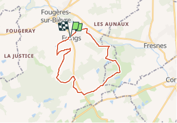

Length
13.9 km

Max alt
120 m

Uphill gradient
102 m
Km-Effort
15.2 km

Min alt
84 m

Downhill gradient
104 m
Boucle
Yes
Creation date :
2023-01-25 15:45:43.079
Updated on :
2023-01-25 15:47:11.379
3h27
Difficulty : Easy
3h27
Difficulty : Difficult

FREE GPS app for hiking
 SityTrail
IGN / Geographical institutes
SityTrail Plus
The world is yours!
About
Trail On foot of 13.9 km to be discovered at Centre-Loire Valley, Loir-et-Cher, Le Controis-en-Sologne. This trail is proposed by mimilolo.
Description
départ parking mairie
Positioning
Country:
France
Region :
Centre-Loire Valley
Department/Province :
Loir-et-Cher
Municipality :
Le Controis-en-Sologne
Location:
Unknown
Start:(Dec)
Start:(UTM)
375852 ; 5255129 (31T) N.
Comments